Enhancing Earth Science Predictions through Advanced Data Assimilation Techniques

March 26, 2023

Improving Earth System Predictions: Assimilating Satellite-Based Observations with Ensemble Kalman Filter and Machine Learning Techniques

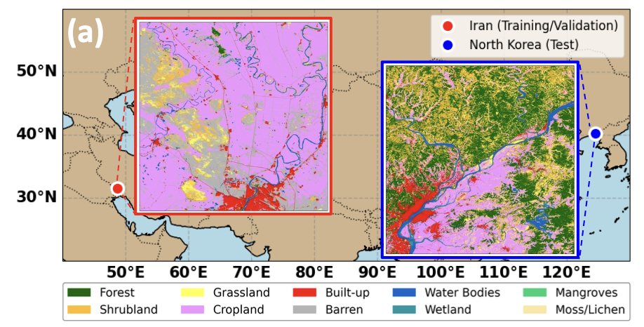
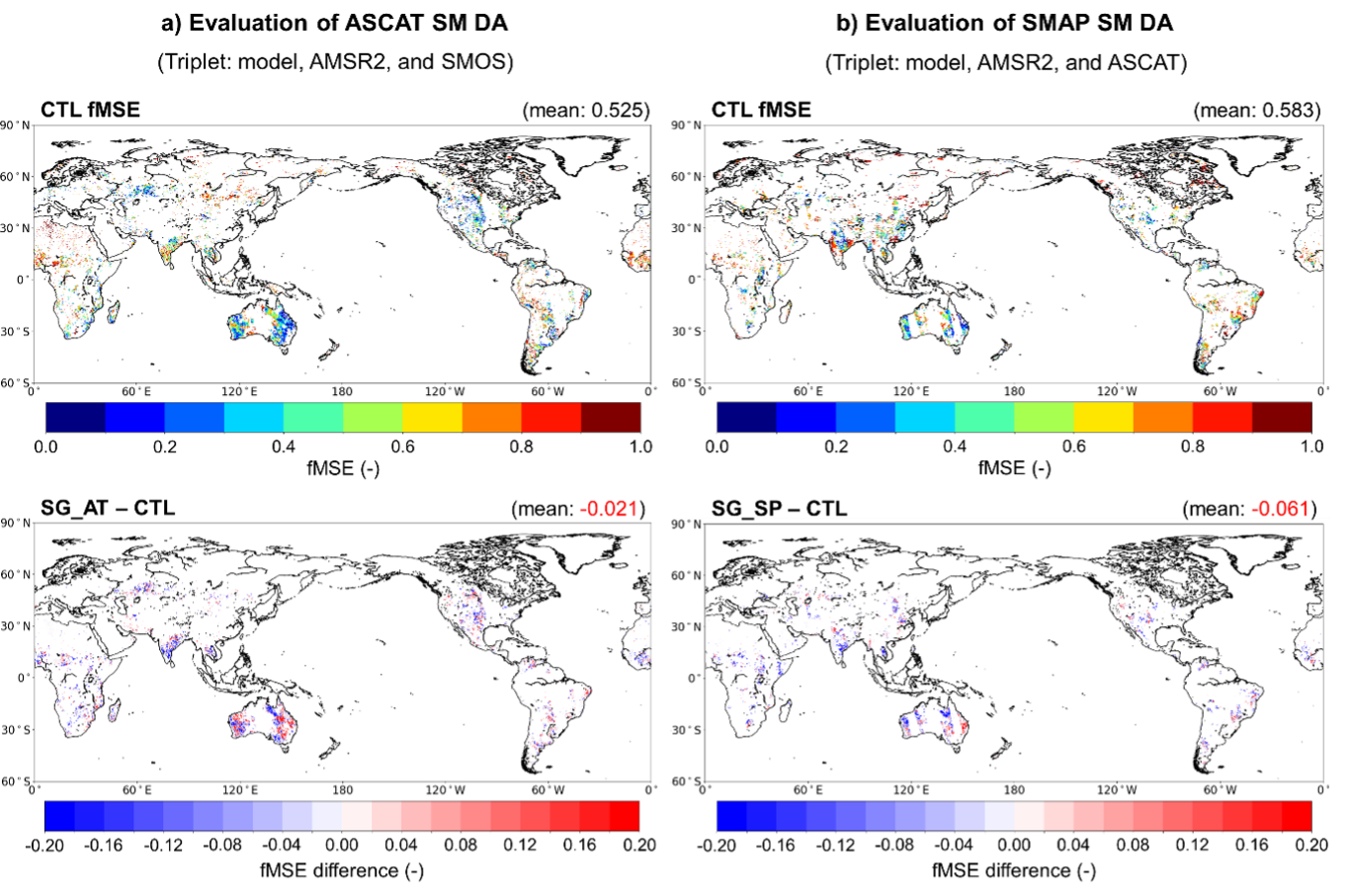
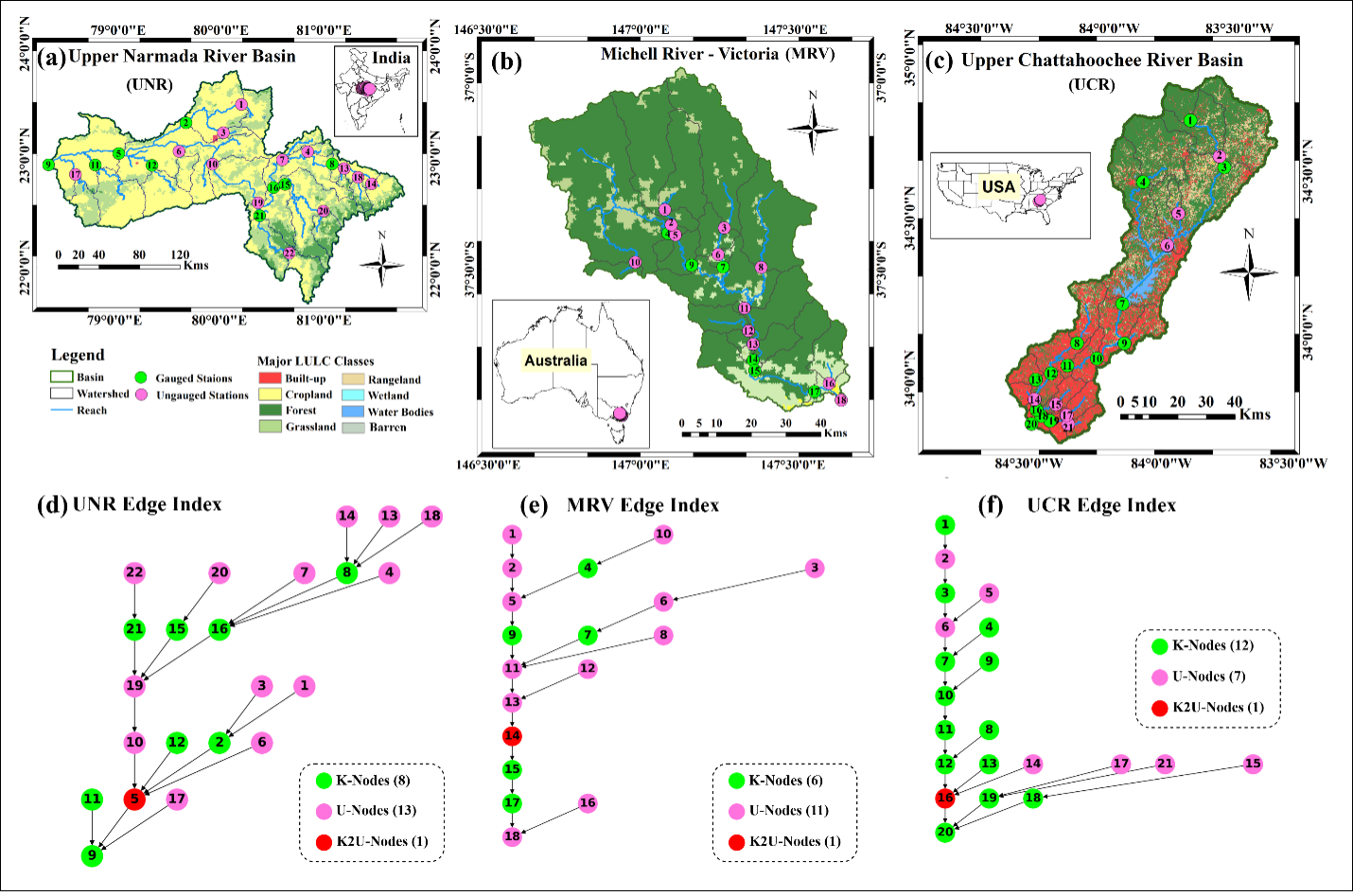
Data assimilation is an advanced method used in Earth sciences to combine observational data, such as those obtained from satellites, with model simulations to generate more accurate and reliable forecasts. It bridges the gap between real-world measurements and theoretical models, allowing scientists to gain a deeper understanding of various Earth systems. In our research lab, we focus on assimilating satellite-based observations of soil moisture, vegetation, and groundwater into a land surface model. To achieve this, we employ the Ensemble Kalman Filter, a sophisticated statistical technique that adjusts model predictions based on real-time data. Additionally, we utilize machine learning techniques to further refine our model, ensuring that our simulations are as accurate and reliable as possible for better decision-making in environmental management and climate adaptation.

Figure shows how the CYGNSS satellite data improves the quality of soil moisture estimations from a land surface model

What we aim to achieve

Through data assimilation, we aim to achieve more accurate and reliable representations of Earth systems, ultimately improving predictions and forecasts for natural disasters such as drought, flood, dust outbreaks, and wildfires. By integrating diverse observational data with model simulations, we can enhance the understanding of complex processes, allowing for better decision-making in environmental management, climate adaptation, natural resource planning, and disaster risk reduction.

Data and analytic skills we use for this project

To perform data assimilation, individuals need a strong foundation in various data and analytic skills, including:

  1. Mathematics and Statistics: A solid understanding of probability theory, linear algebra, and statistical methods is crucial for interpreting and analyzing data in data assimilation.
  2. Numerical Methods: Familiarity with numerical methods, such as interpolation and optimization, is essential for working with large datasets and implementing assimilation algorithms.
  3. Programming: Proficiency in programming languages like Python, R, MATLAB, or Fortran is necessary for data manipulation, model implementation, and analysis.
  4. Earth System Models: Knowledge of the specific Earth system model being used (e.g., land surface) is vital for understanding the processes and variables involved in the assimilation process.
  5. Remote Sensing and GIS: Skills in remote sensing, GIS, and spatial data analysis are important for working with satellite observations and incorporating them into models.
  6. Data Management: Ability to work with large datasets, manage data storage, and handle various data formats (e.g., NetCDF, HDF) is crucial for efficient data assimilation.
  7. Machine Learning and Artificial Intelligence: Familiarity with machine learning techniques and AI algorithms can enhance the assimilation process, providing more advanced methods for model improvement and prediction.
  8. Domain Knowledge: Understanding the specific Earth system domain (e.g., hydrology) ensures accurate interpretation of results and proper application of data assimilation techniques.

We can learn together and we are here to help you develop these skills.

This project aims not only to assimilate satellite data sets into land surface models but also to explore other related research topics below. If you are interested in any of the following research areas, please do not hesitate to contact me!
  1. Multi-source Data Assimilation: Investigate the integration of diverse data sources, such as ground-based observations, satellite remote sensing, and citizen science data, to improve Earth system models.
  2. Data Assimilation in Urban Environments: Study the use of data assimilation techniques to improve urban-scale environmental models, addressing issues like air pollution, heat islands, and urban flooding.
  3. Deep Learning for Data Assimilation: Investigate the potential of deep learning algorithms, such as neural networks, for enhancing data assimilation processes and improving Earth system model predictions.
  4. Uncertainty Quantification in Data Assimilation: Develop novel methods to assess and reduce uncertainties in data assimilation, focusing on both observational data and model predictions.
  5. Ensemble-based Data Assimilation Techniques: Explore the development and application of advanced ensemble-based data assimilation methods, such as particle filters or ensemble-based variational methods, to improve Earth system models.
  6. Data Assimilation in Climate Change Projections: Study the potential of data assimilation to reduce uncertainties in climate change projections and improve the accuracy of future climate scenarios.
  7. Real-time Data Assimilation for Disaster Management: Explore the use of data assimilation techniques for real-time monitoring and forecasting of natural disasters, such as hurricanes, earthquakes, and wildfires, to support early warning systems and disaster risk reduction efforts.
Contact

Read other projects

Harnessing Deep Learning to Predict and Decode the Mysteries of Flash Droughts (GAN/SHAP/3D-CNN with Transfer Learning)

The application of deep learning in predicting flash droughts offers a transformative approach to understanding and anticipating these rapid-onset events, significantly enhancing preparedness and response strategies. By unraveling the complex mechanisms behind flash droughts, this project aims to provide precise, timely forecasts, thereby mitigating the severe agricultural, ecological, and socioeconomic impacts associated with these phenomena.

Read this project
Streamflow and Drought Predictions over Ungaged Regions using Deep and Transfer Learning Approaches

Streamflow and flash drought predictions are essential for managing water resources and mitigating potential disasters in ungaged regions. With remotely-sensed data, deep and transfer learning approaches provide powerful tools to analyze complex hydrological data, enabling more accurate predictions and better decision-making in these areas.

Read this project
Applications of Bayesian Machine Learning in Big Data in Earth Science

Bayesian methods help us improve our guesses by using new information. In Earth science, these methods are applied to big data to better understand our planet. This approach is useful for predicting things like natural disaster patterns and climate changes. By continuously updating our knowledge with new data, we can make more accurate predictions and decisions in Earth science.

Read this project
Water Balance Budgeting with Bayesian Machine Learning

The water balance equation in Earth science, P = E + R + etc, describes the relationship between precipitation (P), evaporation (E), runoff (R), and etc (e.g., soil moisture, ground water) in a given area. Bayesian inference can be applied to solve this equation by incorporating prior knowledge and updating the probability distributions of the variables based on new data, ultimately improving water resource management and prediction.

Read this project
Integrating Earth Science and Engineering for Climate Resilience: Innovative Approaches to Infrastructure and Societal Justice

Earth science informs infrastructure development by providing insights into site suitability, resource management, and sustainable design, enhancing the resilience and long-term viability of projects. It also plays a crucial role in addressing societal justice related to climate change by helping identify vulnerable communities and develop mitigation strategies, ensuring equitable access to resources and protection from environmental hazards.

Read this project
Enhancing Earth Science Predictions through Advanced Data Assimilation Techniques

Data assimilation is vital in earth science as it integrates diverse observations and model simulations, improving the accuracy of forecasts and predictions. This process enhances our understanding of complex Earth systems, enabling better decision-making for environmental management and climate adaptation.

Read this project
Floods and Droughts Predictions using Machine Learning Approaches

Satellite data and machine learning transformed Earth science by predicting and monitoring natural disasters. This combination delivers precise and timely predictions, crucial for mitigating the impacts of events like floods and droughts.

Read this project
Data Error Characterizations

Characterizing the error of satellite data and land surface models is vital in Earth science, as it ensures the accuracy and reliability of information used for monitoring and predicting environmental phenomena. By understanding these errors, scientists can refine data interpretation, enhance models, and ultimately make better-informed decisions about the Earth's complex systems.

Read this project
Developing Algorithms to Improve the Temporal Sampling of Satellite Data

Enhancing the temporal repeat of satellite data for obtaining soil moisture information is a vital research area due to its implications for agriculture, water resource management, climate change research, and ecosystem health. It helps in making informed decisions, increasing productivity, and reducing the impact of natural disasters, as well as contributing to our understanding of the global climate system.

Read this project
Exploring the Impact of Human Activities on the Subdaily Global Terrestrial Water Cycle

Humans have been modifying the Earth's surface for thousands of years, with practices like clearing forests for agriculture and creating uniform land covers. But how do these changes impact the subdaily global terrestrial water cycle? That's the question a project aims to answer.

Read this project
Satellite Image Disaggregation with Machine Learning

Microwave soil moisture data is critical for agriculture, weather, and climate modeling, but has low spatial resolution. Disaggregation via machine learning can improve resolution, offering detailed local soil moisture data. Machine learning can handle complex relationships between microwave signals and soil moisture.

Read this project