Satellite Image Disaggregation with Machine Learning

March 24, 2023

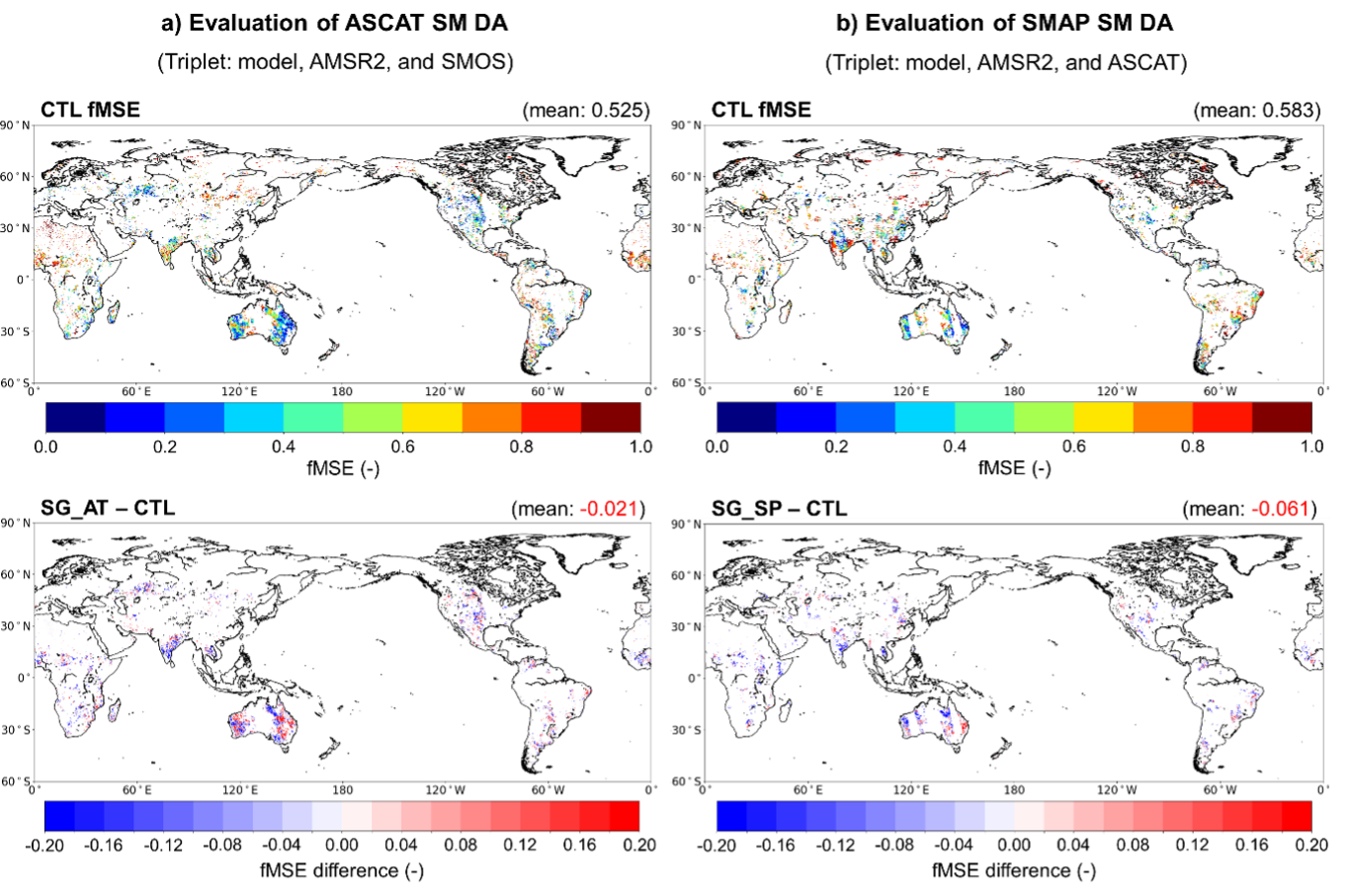
Importance of Machine Learning in Microwave Soil Moisture Data Disaggregation

Microwave soil moisture data from satellite sensors provide crucial information for agriculture, weather forecasting, and climate modeling, but the spatial resolution of these data is often coarse. Disaggregation using machine learning techniques can improve the spatial resolution of these data, providing more detailed information on soil moisture conditions at a local scale. Machine learning algorithms can also learn complex relationships between microwave signals and soil moisture content, which can be difficult to model using traditional techniques.

(left) Coarse resolution soil moisture data (right) disaggregated soil moisture data

What we aim to achieve

We aim to achieve higher spatial resolution and more accurate estimates of soil moisture conditions through soil moisture data disaggregation with various machine learning algorithms. This can help improve our understanding and prediction of droughts, floods, and other weather-related events, as well as aid in agriculture and water resource management.

We are disaggregating soil moisture data using machine learning algorithms, which are trained on a combination of high-resolution soil moisture data and low-resolution microwave satellite data. The algorithm learns the relationship between the two data sets and then applies this relationship to the low-resolution microwave data to estimate soil moisture at a higher resolution. Some common machine learning algorithms used for this task include neural networks, random forests, and support vector machines. Additionally, we can also use auxiliary data such as topography, vegetation, and soil properties to further improve the accuracy of the disaggregated soil moisture data.

Data and analytic skills we use for this project

  • Satellite remote sensing data from various Earth observing satellites including GCOM-W2, Landsat family, and microwave satellite systems
  • Machine learning algorithms, such as neural networks, random forests, and support vector machines
  • Python or R programming for data processing, analysis, and visualization
  • GIS (Geographic Information System) software for spatial data analysis and mapping
  • High-performance computing skills for processing large datasets
  • Knowledge of soil science and hydrology to interpret and validate results
This project aims not only to disaggregate the satellite-based soil moisture data but also to explore other related research topics below. If you are interested in any of the following research areas, please do not hesitate to contact me!
  1. Investigating the effectiveness of different machine learning algorithms for soil moisture data disaggregation, including deep learning models.
  2. Developing new feature extraction techniques to improve the accuracy of soil moisture estimates.
  3. Exploring the use of multi-sensor data fusion techniques to improve the resolution and accuracy of soil moisture data.
  4. Investigating the transferability of machine learning models across different regions and climatic zones.
  5. Developing methods for incorporating uncertainty information into disaggregated soil moisture data.
  6. Investigating the impact of different preprocessing techniques, such as smoothing and denoising, on the accuracy of soil moisture estimates.
  7. Developing methods for integrating high-resolution soil moisture data from ground-based sensors with low-resolution satellite data.
  8. Exploring the use of other microwave satellite data, such as synthetic aperture radar (SAR), for soil moisture data disaggregation.
  9. Developing methods for estimating soil moisture profiles using machine learning techniques.
  10. Investigating the use of disaggregated soil moisture data for improving hydrological modeling and water resource management.

Contact

Read other projects

Harnessing Deep Learning to Predict and Decode the Mysteries of Flash Droughts (GAN/SHAP/3D-CNN with Transfer Learning)

The application of deep learning in predicting flash droughts offers a transformative approach to understanding and anticipating these rapid-onset events, significantly enhancing preparedness and response strategies. By unraveling the complex mechanisms behind flash droughts, this project aims to provide precise, timely forecasts, thereby mitigating the severe agricultural, ecological, and socioeconomic impacts associated with these phenomena.

Read this project
Streamflow and Drought Predictions over Ungaged Regions using Deep and Transfer Learning Approaches

Streamflow and flash drought predictions are essential for managing water resources and mitigating potential disasters in ungaged regions. With remotely-sensed data, deep and transfer learning approaches provide powerful tools to analyze complex hydrological data, enabling more accurate predictions and better decision-making in these areas.

Read this project
Applications of Bayesian Machine Learning in Big Data in Earth Science

Bayesian methods help us improve our guesses by using new information. In Earth science, these methods are applied to big data to better understand our planet. This approach is useful for predicting things like natural disaster patterns and climate changes. By continuously updating our knowledge with new data, we can make more accurate predictions and decisions in Earth science.

Read this project
Water Balance Budgeting with Bayesian Machine Learning

The water balance equation in Earth science, P = E + R + etc, describes the relationship between precipitation (P), evaporation (E), runoff (R), and etc (e.g., soil moisture, ground water) in a given area. Bayesian inference can be applied to solve this equation by incorporating prior knowledge and updating the probability distributions of the variables based on new data, ultimately improving water resource management and prediction.

Read this project
Integrating Earth Science and Engineering for Climate Resilience: Innovative Approaches to Infrastructure and Societal Justice

Earth science informs infrastructure development by providing insights into site suitability, resource management, and sustainable design, enhancing the resilience and long-term viability of projects. It also plays a crucial role in addressing societal justice related to climate change by helping identify vulnerable communities and develop mitigation strategies, ensuring equitable access to resources and protection from environmental hazards.

Read this project
Enhancing Earth Science Predictions through Advanced Data Assimilation Techniques

Data assimilation is vital in earth science as it integrates diverse observations and model simulations, improving the accuracy of forecasts and predictions. This process enhances our understanding of complex Earth systems, enabling better decision-making for environmental management and climate adaptation.

Read this project
Floods and Droughts Predictions using Machine Learning Approaches

Satellite data and machine learning transformed Earth science by predicting and monitoring natural disasters. This combination delivers precise and timely predictions, crucial for mitigating the impacts of events like floods and droughts.

Read this project
Data Error Characterizations

Characterizing the error of satellite data and land surface models is vital in Earth science, as it ensures the accuracy and reliability of information used for monitoring and predicting environmental phenomena. By understanding these errors, scientists can refine data interpretation, enhance models, and ultimately make better-informed decisions about the Earth's complex systems.

Read this project
Developing Algorithms to Improve the Temporal Sampling of Satellite Data

Enhancing the temporal repeat of satellite data for obtaining soil moisture information is a vital research area due to its implications for agriculture, water resource management, climate change research, and ecosystem health. It helps in making informed decisions, increasing productivity, and reducing the impact of natural disasters, as well as contributing to our understanding of the global climate system.

Read this project
Exploring the Impact of Human Activities on the Subdaily Global Terrestrial Water Cycle

Humans have been modifying the Earth's surface for thousands of years, with practices like clearing forests for agriculture and creating uniform land covers. But how do these changes impact the subdaily global terrestrial water cycle? That's the question a project aims to answer.

Read this project
Satellite Image Disaggregation with Machine Learning

Microwave soil moisture data is critical for agriculture, weather, and climate modeling, but has low spatial resolution. Disaggregation via machine learning can improve resolution, offering detailed local soil moisture data. Machine learning can handle complex relationships between microwave signals and soil moisture.

Read this project